In the vicinity of the proposed Arles highway bypass, 437 hectares of peatland have been identified. The soil, which is up to 8,000 years old, stores a significant amount of carbon and supports a variety of endangered species.
Arles (Bouches-du-Rhône), report
Why the 12-5-30 Incline Walking Method Is the Ultimate Fat-Burning Workout, According to Fitness Experts
The ultimate trick to banish mold from your bathroom grout in just 7 minutes—no vinegar or baking soda needed
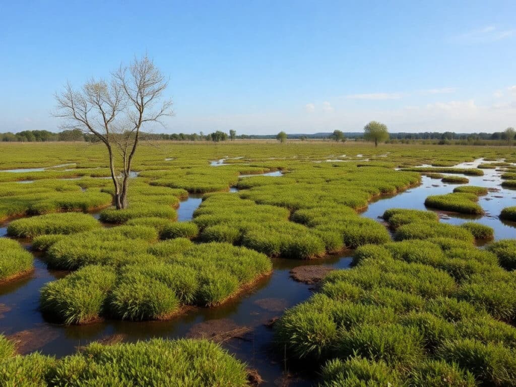
« You’re going to feel the ground shake. » In a pasture 11 km east of Arles, a group of Camargue horses gallops rapidly towards us. Indeed, as they draw closer at the end of March, the ground begins to tremble slightly. « We’re standing on 80 cm of peat beneath our feet. », explains Virgile Alexandre, who runs the Ganaderia El Campo, a bull-breeding ranch for bullfighting. The horses assist him in managing his cattle. The ground here is soft and moist, resembling a sponge. The 60 hectares of the ranch are located next to a rare 437-hectare peat bog in the marshes of Chanoines and Meyranne. However, this remarkable ecosystem could vanish due to the Arles highway bypass project: a 26 km stretch of asphalt planned by the state for over thirty years.
This would complete the highway corridor between Spain and Italy, thereby relieving the RN 113, which currently burdens the city center with its noise and congestion. The new infrastructure could alter the patterns of groundwater flow, the effects of which remain unknown due to inadequate studies. On the northern edge of the bull pastures, the constant rumble of trucks on the RN 113 is relentless. Here, the state intends to expand the roadway to make room for the highway.
This reduction in water availability would be catastrophic for the marshes, which are significant carbon sinks. In peatland soils, which should be perpetually water-saturated, dead plant matter does not fully decompose. However, when peatlands are compromised by a water deficit, they can also release CO2 into the atmosphere very quickly.
« Globally, the degradation of peatlands accounts for 4 % of greenhouse gas emissions. That’s more than civil aviation [about 2.5 %] », states Antoine Gazaix, a plant ecology researcher at Tour du Valat, a wetland research institute based in Camargue.
In early 2026, the Tour du Valat released a report on the peatlands of the Rhône delta geological area. Stretching from Saint-Gilles (Gard) to Fos-sur-Mer (Bouches-du-Rhône), they cover 2,248 hectares with an estimated carbon stock of « 1.27 million to 3.83 million tonnes, equivalent to the carbon contained in 15,000 to 50,000 hectares of temperate forests », explains Antoine Gazaix. The inventory was part of a national study coordinated by the University of Franche-Comté, which will result in the publication of a national peatland atlas by 2026.
Using a soil auger, the ecologist extracts a core of soil, revealing layers of dark earth and light gray sand. « The heavy, gray material is sediments from the Rhône brought by floods. The much darker material contains lots of root remnants and fairly large pieces of stems. That’s the peat, describes Antoine Gazaix. It’s mostly reeds. »
This is a record of past vegetation, for there are no reeds in sight. « We are on an old channel of the Durance. This valley was filled by peat », continues Antoine Gazaix. This river once flowed directly to the sea tens of thousands of years ago before geological shifts redirected its course towards the Rhône, which it joins south of Avignon. « The deepest layer of peat, 6 meters below us, formed 8,000 years ago », he asserts.
At the end of February, the Arles bypass project, which the prefect must declare as a public utility or not, nevertheless received a significant setback. The report from the commissioners following the public inquiry held this winter is entirely unfavorable, especially regarding the « internationally important wetlands » of the Arles region.
« Several scientific bodies consider that certain unique environments, [like] some peatlands, have technically irreplaceable characteristics », states the report. In other words, if they were destroyed, they would be lost forever. The commissioners found the state’s dossier to lack sufficient environmental protections, particularly regarding « the preservation of the hydrological balances of the territory ».
In this unique environment, water emerges through resurgences, bursting from the ground through large holes formed in the roof of the Crau plain’s aquifer. These are called « laurons ». With the highway potentially disrupting the underground water flow, « the laurons may no longer be as active », fears Grégoire Massez, curator of the Meyranne marshes site managed by the League for the Protection of Birds (LPO).
The aquifer itself is replenished by 70 % through the irrigation of Crau hay meadows, according to the aquifer management union (Symcrau). Water drawn from the Durance and delivered via canals floods the meadows, leading to infiltration into the aquifer. « The sealing of soils and the destruction of irrigated meadows [by the highway] could significantly reduce the recharge of this aquifer », note the commissioners.
Moreover, current hydrological conditions are already under threat from climate change. The Chanoines and Meyranne marshes could undergo significant transformations according to the Osmose 2 study, a 2023 projection of future water supplies for wetlands published by Symcrau.
In a scenario with a 30 % reduction in irrigation inputs, water flows from resurgences would decrease by 40 %. This would likely result in « the probable maintenance of permanent waterlogging » 1 meter below the soil surface and « potentially at the natural ground level in the lowest areas ». During the 2022 drought, whose severity is expected to become more common according to several scientific projections, irrigation was restricted by 25 % by a prefectural order.
In a scenario of complete cessation of irrigation, the study predicts an « evolution towards wet meadows and then willow groves, with possible maintenance of laurons downstream of the marsh ». The peatland, dependent on the laurons, would be greatly diminished.
Yet, this environment serves as a refuge for endangered species, such as the bittern (Botaurus stellaris), a vulnerable wading bird. Of the estimated 100 singing males in France, half are located in the Arles region.
Plants typically found in mountainous regions also thrive here, thanks to the cool water emerging from the laurons. « It remains at 15°C all year round, which is remarkable », observes rancher Virgile Alexandre. « We find marsh fern [Thelypteris palustris] and marsh gentian [Gentiana pneumonanthe], which produces small blue flowers », adds Antoine Gazaix.
The area is also home to several orchids, but the small Loesel’s twayblade (Liparis loeselii), threatened with extinction in Europe, is no longer found. « The orchid was destroyed with the construction of the RN 113 [inaugurated in 1990]. Everyone is pretty much convinced that it’s over, we won’t find it here again. In the region, it still exists in the Hautes-Alpes », says Grégoire Massez from the LPO. To prevent history from repeating itself, the scientist and the natural area manager hope that this rare Mediterranean peatland will be more extensively studied and better protected.
Similar Posts
- One in Five Wetlands Could Vanish by 2050: Global Environmental Crisis Looms
- Gironde’s 2022 Fire Aftermath: Witnessing Nature’s Remarkable Resilience
- Beavers Boost CO₂ Storage Tenfold in Wetlands: Nature’s Engineers Combat Climate Change
- Reviving Berre Lagoon: Association Replants Vital Seagrass Meadows
- Endangered Bird Faces Extinction: High-Voltage Power Line Threatens Rare Ganga Cata

Hi, I’m Ashley from the Decatur Metro team. I share essential information for a sustainable and responsible lifestyle.