
Allen Wilson Redevelopment Continues Thanks to Additional Tax Credits
Decatur Metro | January 16, 2013As construction/demolition continues at Allen Wilson Terrace, I found these renderings from the latest Decatur Focus a good reminder of what’s left to be built…
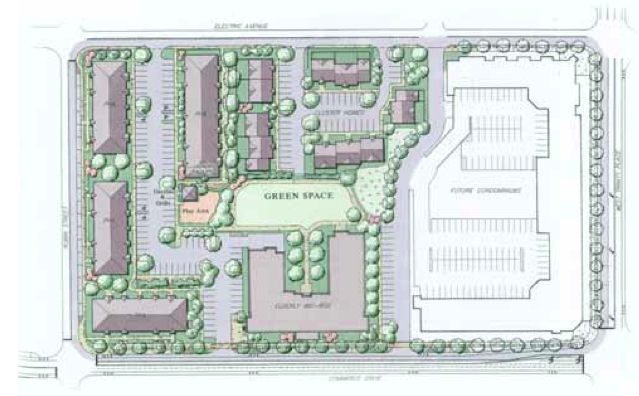
Phase III is currently under construction along Electric Avenue…I believe I posted a pic of that work recently. Additionally, according to the Focus…
The Decatur Housing Authority has been selected by the Georgia Department of Community Affairs to receive an allocation of Low Income Housing Tax Credits for Allen Wilson Phase III. In Phase III, the DHA will build the final 71 affordable units, with a completion date of December 2013, and move the Allen Wilson Terrace families into the new units. The plan then calls for demolishing the old units along Trinity and developing market rate housing along that side of the site.


The “Old P” will soon be gone! I wonder what the slang name for the new development will be? Could be an interesting contest.
Wow. You know that expression! When my kids were little, all their friends from Allen Wilson Terrace referred to themselves as the OPs, as in the OP bus or “we live in the OPs”. I asked around and none of their parents seemed to know what that was about. A babysitter who grew up there didn’t know either. Now I realize that OP stood for “Old P”. What did the “P” stand for? “Projects”? That’s what a lot of folks guessed. Never hear OP anymore. I think it got replaced by “DHA housing” or “Trinity”.
It still pisses me off that this area remains a cul de sac. It increases the traffic (and danger) on Howard Ave. considerably. For what?
Agreed. Why can’t this aread be inerconnected with the rest of the ciy?
Which cul-de-sac are you referring to? Robin and White St? If so, we’ve asked similar questions about extending Fairview from Ponce to Trinity here in the past and why the Gateway Apts property is totally cut off from the rest of downtown.
also agree…seems poorly designed site plan to me. Looks like a suburban typology in an urban context which is always disappointing. Maybe the piece to the north will be different…but I can see this development being replaced like the previous development in 40 years. Too bad.
You know why … And take a look at aerial maps (Google works) to see where the area used to be connected (by Thinking Man, for example) and take a guess when the exits/entrances were fenced.
I’m all for connectedness. Especially since the lack of connectedness increases the amount of time it takes me to get across that part of town on bike. If children with me, every 1/4 mile counts!
However, I wonder about the impact of an increase in traffic on that neighborhood given a lot of pedestrians and kids playing outside. Safety issue? Noise issue? Just a thought. Not a deal killer but a factor that should be considered and taken into account.
A street not connected creates more traffic on streets that are. Our neighborhood deals with Adair St being a major cut through but if Atlanta Ave had never been closed then it would be less used. Of course that was a long time ago.
Yep. The restoration of Atlanta Ave. would be a boon on multiple fronts. Of course, it would require the demolition of a gated subdivision, so I wouldn’t count too much on that one.
Any old-timers know: Did Robin Street used to connect with Atlanta Ave.? What about White Street.?
Robin St. extended from Atlanta Ave. to N. McDonough. It was closed on the N. McDonough side in 1952 when the Decatur High stadium was expanded. Old Timer.
Thank you, sir!
Did it terminate opposite E Maple St? If so, wonder why E Maple was not also Robin? Or why was Robin not W Maple (there is no W Maple)? E Maple is also an old street name.
Perhaps for the same reason Briarcliff turns into Moreland, whatchacallit into Rocky Ford, etc?
Thanks UDog. I am familiar with this street (Robin Street from McDonough to Atlanta) because when I first started teaching at DHS in 1976 and I worked the football games, the so called tunnel under the 1953 stadium addition was always open (people could walk under the stadium- there were no gates). Why? I was told that “this is a road that cannot be blocked”. Sometime in the 1980s, gates were added to closed off the tunnel.
Today’s White Street (interesting name) did not exist or connect to Electric. There was a street, it may have been named White St., that continued from the westernmost section Greenwood Circle, then turned and mostly paralleled Robin and Greenwood and extended east to what is now the driveway connecting the upper and lower parking lots of the high school. It dead ended at Robin St. at the football field.
I know why historically this area was cut off, but hopefully that will change. To be fair, it is the Gateway Apartments that landlock this section of town. The 2010 Master Plan calls for redeveloping Gateway, extending Fariview and adding a new street parallel to ponce that bisects the Gateway parcel.
Any plans to actually do this? Maybe after the redevelopent of Allen Wilson and the new municipal center, this will become a priority.
The apartments along Commerce Drive were two separate complexes. Allen Wilson Terrace was the oldest and simply called the “Projects”. When Swanton Heights was later built, Allen Wilson Terrace was then referred to as the “OPs” short for “Old Projects” as opposed to the new Swanton Heights complex to explain which complex to which you were referring.
A mystery finally solved. Thanks.